Updated @ 3:19 PM EDT on August 19, 2025
Hurricane Erin is spinning toward the Bahamas and the United States, and communities along North Carolina’s Outer Banks are under storm surge and tropical storm watches.
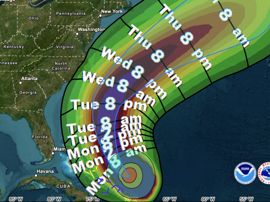
According to a National storm Center advisory, Erin is still a strong Category 4 storm as of Monday night, with sustained winds close to 140 mph. The hurricane is expected “to pass to the east of the southeastern and central Bahamas today and tonight, and move between Bermuda and the east coast of the United States by the middle of the week,” according to the warning.
NHC Deputy Director Jamie Rhome stated in an update that Erin would have a major impact on the mid-Atlantic region, particularly the Outer Banks, even if it is not expected to make landfall in the United States. In North Carolina, there is a tropical storm watch from Beaufort Inlet to Duck, including Pamlico Sound, and a storm surge watch from Cape Lookout to Duck.
“Breaking waves of 15 to 20 feet plus coastal flood and storm surge could overwash dunes and flood homes, flood roads and make some communities impassable,” he stated.
The Outer Banks should be ready for days of possible flooding, according to forecasters at the National Weather Service office in Morehead City, North Carolina, on Monday night.
“Coastal flooding will likely be a long duration issue, impacting Highway 12,” the National Weather Service office said, indicating that portions of the key route along the Outer Banks may be impassable for a number of days.
A mandatory evacuation order for all tourists to Ocracoke and Hatteras islands was announced by the North Carolina Department of Transportation on Monday morning. The order will go into force for locals early on Tuesday.
Officials in Hyde County, North Carolina, declared a state of emergency for Ocracoke Island on Sunday, cautioning that in the event that Highway 12 becomes inaccessible, emergency services could not be available. A state of emergency was proclaimed for the entire county of Dare to the north.
As it advances north, Erin is increasing the likelihood of large waves and hazardous rip currents along the eastern U.S. shoreline from Florida to Massachusetts, according to forecasters on Monday.
After rapidly intensifying over the weekend into a Category 5 hurricane with winds of around 160 mph, Erin has somewhat lessened. Although Erin’s strength has been fluctuating, experts anticipate that it will continue to be a strong storm as it moves closer to the United States, increasing the likelihood of flooding and other effects.
Hurricanes are becoming more strong on average due to climate change. Generally speaking, warmer and more humid air gives extreme weather—from hurricanes to powerful inland storms—greater fuel.Warm ocean temperatures, according to experts, can also aid storms in carrying large amounts of water, increasing the likelihood of flooding, which is the primary cause of hurricane-related fatalities.
Following a sluggish start to the 2025 season due to a number of tropical storms, Erin is the first Atlantic storm of the season to achieve hurricane status. There are indications that the season might be intensifying at this point: Over the next week, the National Hurricane Center says it is keeping an eye on a tropical wave that may turn into a storm over the eastern Atlantic.
Copyright 2025 NPR


