Updated @ 6:23 PM EDT on August 20, 2025
As Hurricane Erin creeps north, hundreds of miles off the East Coast, her effects are already being felt in North Carolina’s Outer Banks.
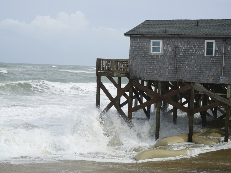
By Wednesday afternoon, portions of Highway 12, which runs across the Outer Banks, were already inundated. Additionally, officials have closed the evacuation window for locations that are at risk because they anticipate that the storm’s strongest effects would occur during the evening’s high tides. They advised the remaining people to stay put.
The islands of Hatteras and Ocracoke are subject to mandatory evacuations.
According to the National Hurricane Center, the enormous storm was about 295 miles away from Cape Hatteras, North Carolina, at 5 p.m. ET. The Newport/Morehead City office of the National Weather Service described it as a “large and dangerous hurricane.”
From Cape Lookout to Duck, North Carolina, a storm surge warning is in force. From Beaufort Inlet, North Carolina, to Chincoteague, Virginia, encompassing the Pamlico and Albemarle sounds, a tropical storm warning is in force.
“Coastal flooding, storm surge, and overwash has already begun,” the NWS Newport/Morehead City office stated Wednesday afternoon, announcing a “long duration event” for the Outer Banks. Although some locations may have effects through Friday, the NWS stated that the storm’s effects should peak Wednesday night into Thursday.
Although first responders were ready to react to cries for assistance from those who remained, conditions might prevent them from doing so, Hatteras Island Rescue Squad Chief Jack Scarborough cautioned.
In a video released by the government of Dare County, he stated, “If water begins to encircle your home, move to the highest level and stay there until it starts to recede.” “Do not think it’s over after the first high tide conditions could persist into Friday.”
Josh Stein, the governor of North Carolina, has proclaimed a state of emergency.
Because Erin is so large and is sending tropical storm-force winds up to 265 miles from its core, forecasters warned that its effects might be felt far from home.
People on the East Coast who were thinking of swimming at beaches were warned by federal authorities.
“Beachgoers are urged to follow information from lifeguards, local authorities, and beach warning flags,” the National Hurricane Center wrote in a post on X. “The best guidance? Don’t go into the water!”
Beaches in Atlantic Canada, the Bahamas, Bermuda, and the East Coast are expected to experience rip currents and waves. According to the National Hurricane Center, “these rough ocean conditions are expected to cause life-threatening surf and rip currents.”
According to the National Ocean Service, rip currents are “powerful, narrow channels of fast-moving water” that can put swimmers in danger if they attempt to swim quickly back to land. Swimmers caught in a rip current are advised by the agency to attempt swimming parallel to the shore and returning to shore at an angle.
There was a high risk of rip currents from Florida to Massachusetts on Thursday, according to an NHC map.
Erin is expected to remain a hurricane over the weekend, although forecasters predicted it may get stronger over the course of the following day and then weaken by Friday.
Research indicates that although the frequency of hurricanes has not increased recently, the intensity of these storms has increased.
Storm severity is increased by warmer ocean temperatures brought on by human-caused climate change, which results in more fatalities and billions of dollars in property damage.
In recent years, North Carolina has had several catastrophic hurricanes, such as Hurricane Helene last year, which left the state with at least 108 fatalities and losses of around $60 billion.
Copyright 2025 NPR


