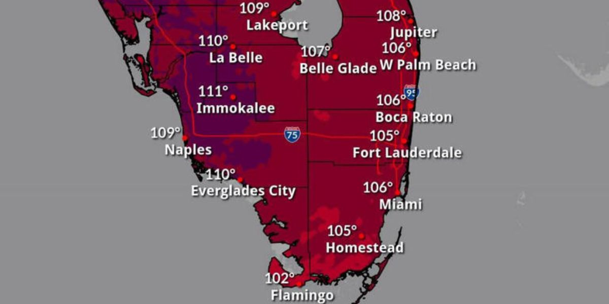
TAMPA, Fla. — A potentially dangerous heat wave is set to intensify across West Central and Southwest Florida this weekend and into early next week, with heat index values expected to reach between 104°F and 111°F by Tuesday, according to the National Weather Service in Tampa Bay.
From Sarasota and Lakeland to Fort Myers and Sebring, both coastal and inland communities are expected to endure oppressive heat and humidity, making outdoor conditions hazardous—especially during the peak afternoon hours.
Extreme Heat Risk Through at Least Tuesday
Beginning Sunday, forecasters say actual air temperatures will climb into the mid to upper 90s, while the combination of heat and humidity will push feels-like temperatures well above 100°F, peaking at or near 111°F in some areas. This sustained heat wave poses a significant threat to public health, particularly for:
- Young children and older adults
- People with chronic illnesses
- Outdoor workers
- Those without access to air conditioning
Health and Safety Guidance
Local health officials are urging residents and visitors to:
- Stay indoors during the hottest part of the day, typically between 1 p.m. and 6 p.m.
- Hydrate frequently, even if not thirsty
- Avoid strenuous outdoor activities
- Wear light, loose-fitting clothing
- Use fans or air conditioning whenever possible
Anyone experiencing symptoms of heat exhaustion or heat stroke—such as dizziness, nausea, rapid heartbeat, confusion, or fainting—should seek immediate medical attention.
Read Also: Severe Storms With High Winds to Sweep From Dakotas to New England
Heat Hazards on Roads and Infrastructure
The extreme heat may also impact travel and infrastructure. Roads such as Interstate 75, U.S. 41, and State Road 70 could see an uptick in vehicle breakdowns, tire blowouts, and engine overheating due to prolonged high temperatures.
Drivers are reminded to:
- Check coolant and tire pressure
- Never leave children or pets in parked cars
- Keep emergency supplies like water, shade, and chargers in vehicles
Ongoing Monitoring and Future Advisories
This heat wave may mark one of the most extreme stretches of the summer for the region, and the National Weather Service warns that more heat advisories or warnings may be issued if the trend persists into midweek or beyond.
Local agencies and emergency managers continue to monitor the situation closely and may activate cooling centers or public heat relief stations in at-risk communities.


