The forecasters are warning that the warmest stretch of the summer will begin this weekend and continue into the following week. Temperatures are projected to rise substantially across the entirety of North Georgia over the next several days.
Thursday and Friday will see high temperatures in the upper 80s and low 90s across the region, but by Sunday and Monday, those temperatures will have risen to the upper 90s and will be fairly close to 100 degrees.
There is a possibility that the heat index may reach between 100 and 105 degrees, with some areas in east-central Georgia seeing temperatures that are considerably higher.
The likelihood of precipitation will be low, and the temperature will continue to rise steadily across the board.
Focus on the local level
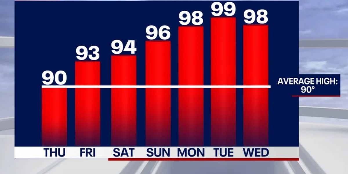
When it comes to Atlanta, the highs will go from 90 on Thursday to 99 by Monday. There is still a low probability of precipitation, with only a thirty percent chance of afternoon storms through Friday.
Temperatures in Rome are expected to rise from the mid 90s on Thursday to 98 degrees on Monday, with the possibility of isolated showers occurring each afternoon.
According to LaGrange, the highs will rise from 87 on Thursday to well over 90 by Monday. Thursday is the day with the highest probability of precipitation, with a sixty percent chance of storms.
According to the prediction for Eatonton, temperatures are expected to hit 102 degrees by Monday, and heat index readings are expected to exceed 100 as early as Thursday.
There is a daily risk of isolated storms in Athens, and high temperatures will soar from 90 to around 100 degrees throughout the course of the weekend.
Read Also: Iowa Weather Warning: Heat Index Near 105°F for Davenport, I-80 Region Thursday
Expect the temperature to continue to rise steadily, reaching a high of approximately 99 degrees on Monday. Storms that arrive in the afternoon can provide some relief.
Temperatures in Blairsville will continue to be slightly lower than those in the rest of the region, but they will still soar into the mid-90s by Monday. There is a daily risk of thunder and lightning.
The authorities are urging the people to take precautions against the prolonged heat by drinking plenty of water, minimizing their time spent outside during peak hours, and keeping an eye on their old or fragile neighbors.


