Recurrent downpours and the possibility of flash flooding are expected to continue throughout next week in the area spanning from the central Plains to portions of the Mississippi and Ohio Valley to the Appalachians.
The Atlantic Seaboard will also experience some extension of the heavy downpours.
First, when a tropical rainfall over the north-central Gulf coast advances inland and gets torn as it moves north, tropical air will be injected over the Mississippi Valley throughout this weekend.
But the moisture from the Gulf will help the moisture that is already present across the Midwest.
A front that moves in from Canada will then interact with that moisture. The push of the chilly air to the north will cause the front to droop southward before lifting northward and finally leaving. Along that front, ripples—mini storm systems—will travel from northwest to southeast.
The blocked frontal zone and Gulf moisture will release a lot of moisture into the sky, causing heavy to locally severe thunderstorms and torrential downpours.
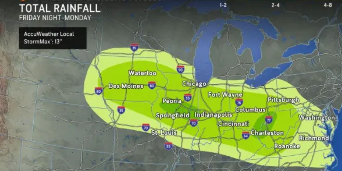
From Saturday to Monday, this area will see an average of 1-4 inches of rain, with some areas seeing up to 13 inches.
Recent severe rainfall from Iowa to West Virginia, Pennsylvania, Maryland, and Virginia, among other places, can exacerbate dangerous flash flooding.

Storm drainage systems may be overwhelmed by rainfall rates of two to three inches per hour during the most heavy downpours.
Isolated thunderstorms can deliver extremely localised flash flooding from the interior Southwest to the Great Lakes and the mid-Atlantic and Gulf coasts, but through Saturday, some of the most concentrated flash flooding zones will stretch from the middle Plains to the Ohio Valley.
The Las Vegas, Nevada, area is one that is at risk for severe flash floods on Thursday night.
A wave of heavy rain with localised flash flooding is expected to travel from the northern Appalachians to parts of New England and the upper mid-Atlantic coast on Saturday night and Sunday. This is due to the return of humid air after a calm.
Some streets, highways, and rural roads throughout the countryside may get submerged if the rain continues for several hours at a high intensity for around an hour.
A potentially hazardous trend that is favourable for both severe thunderstorms and recurrent downpours from the North Central states to the East is expected to form throughout the course of the following week.
There will be a huge heat dome, or area of high pressure, that extends from the Southwest to the southern Plains. Storms are likely to avoid the Texas Hill Country, which has been devastated by flooding, thanks to this heat dome.
On this heat dome’s eastern and northern edges, thunderstorm rounds could thrive. In addition to damaging wind events, the storms are expected to bring with them rounds of intense rainfall and further flash flooding.
Flash flooding accidents have been extremely common so far this year, and this year is already one of the most common.


