Raleigh, N.C. — A dangerous and prolonged stretch of extreme heat is poised to blanket much of North Carolina beginning Friday, with “feels-like” temperatures projected to soar past 112°F in parts of the state.
The National Weather Service (NWS) in Raleigh is urging residents to take immediate precautions as the region faces one of the most intense heat waves of the season so far.
A combination of sweltering daytime highs, high humidity, and limited overnight cooling will create oppressive conditions that could last through early next week, placing millions at risk for heat-related illnesses and straining energy systems statewide.
Forecast Highlights:
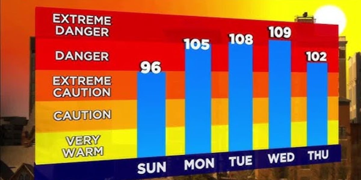
- Actual Temperatures: Expected to range between 95°F and 102°F, particularly in southern and eastern counties.
- Heat Index Values: Could reach 107°F to 112°F or higher, even in shaded areas.
- Affected Areas: Including but not limited to Fayetteville, Laurinburg, Goldsboro, Clinton, Lumberton, and Greenville.
- Timing: Dangerous heat conditions will persist from late morning through evening hours, especially between 11 a.m. and 5 p.m. daily.
“This level of sustained heat combined with humidity poses serious health risks,” warned NWS meteorologists in Thursday’s update. “Conditions could be dangerous for anyone without access to cooling or hydration.”
Health and Safety Concerns
Officials warn that this heat wave could lead to a spike in heat exhaustion, heat stroke, and dehydration, especially for:
- Young children
- Older adults
- Outdoor workers
- Those without air conditioning
Additionally, direct sunlight may cause body temperatures to rise more quickly than expected, even during short periods outdoors.
Read Also: Dangerous Heat in DC Friday: Index Could Hit 109°F Between 11 a.m. and 8 p.m.
To stay safe, residents are advised to:
- Avoid strenuous outdoor activity during peak heat hours
- Drink water regularly, even if you’re not thirsty
- Wear light, loose-fitting clothing
- Check on elderly neighbors and those with chronic illnesses
- Never leave children or pets in vehicles, even for a few minutes
Cooling centers and public spaces such as libraries and malls may be available in some communities for those without air conditioning.
Chance of Thunderstorms Offers Little Relief
While isolated to scattered thunderstorms are possible—especially along the U.S. 401 and I-95 corridors—they are not expected to provide sustained relief.
Brief rainfall may lower temperatures temporarily but could be followed by increased humidity once the sun returns.
Infrastructure Strain Possible
With air conditioning usage expected to surge, local power grids may come under increased stress, particularly during afternoon and evening hours. Residents are encouraged to conserve energy where possible and prepare for potential rolling outages or service interruptions.
Outlook Through the Weekend and Beyond
This will be one of the longest and hottest periods North Carolina has experienced this summer, particularly across southern and coastal plains counties. The heat advisory area may expand as conditions worsen or persist into early next week.
Residents should continue to monitor updates from:
- The National Weather Service
- State and local emergency management agencies
- Utility companies and local governments
Stay alert, stay hydrated, and stay cool. For more information on heat safety, visit weather.gov/safety/heat or follow your local emergency management office.


