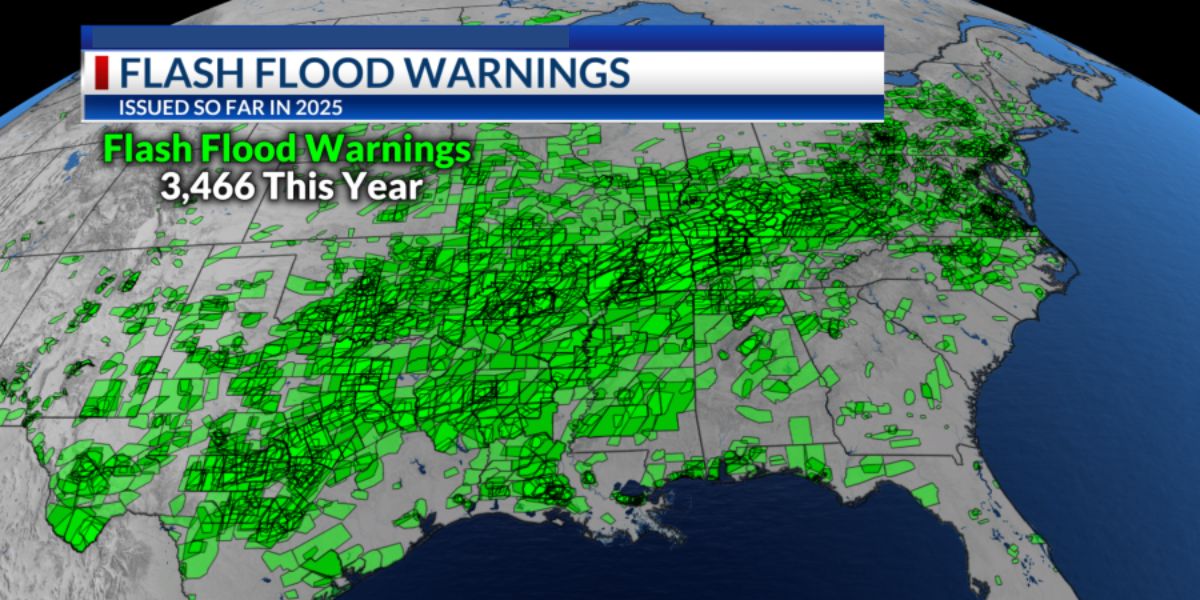
The United States has had the highest number of flash flood warnings since the 1980s as of July 2025.
In the 1980s, the National Weather Service (NWS) formally started monitoring the data. 3,466 warnings have been issued in the Continental United States, which includes the lower 48 states.
When rainfall totals in a particular area above a threshold—which can vary depending on a number of factors, including past rainfall and current rainfall rates—a flash flood warning is issued.
These warnings can also be utilized for other situations, such as abrupt elevations in creeks and streams.
This year, there were more flash flooding incidents due to a number of variables. The condition of the El Niño-Southern Oscillation, or ENSO, would be one indicator.
El Niño occurs when the water temperatures are higher than normal. La Niña is the term used to describe periods of colder-than-normal Pacific seas west of South America.
Since neither El Niño nor La Niña is present at the time of publication, ENSO is regarded as neutral.
This neutral state resulted in no particular pattern for the weather pattern across the United States, with the upper-level winds hovering around 30,000 feet above the land. Another frequent name for these winds is the jet stream.
This summer, the jet stream swiftly moved north toward Canada. As a result, when storm systems hit an area, they move slowly.
The Bermuda High, a region of high pressure that is always located off the U.S. East Coast, was permitted to intensify and further decelerate storm systems.
Additionally, a stronger Bermuda High brought in more humid, warm air, which increased the amount of rainfall in storm systems.
Much of the Eastern United States had more intense rainfall as a result of all these variables. The highest rainfall is predicted for late spring through early October because warmer air retains more moisture.
Read Also: Hazy Days Ahead: Air Quality Alert and Burn Ban in Place Through Friday
Three broad categories can be used to classify flooding in the Coastal Empire and Lowcountry: coastal flooding, urban flooding, and rural flooding.
The kind of flooding that occurs in hillier regions like Central Texas is not what we see.
When an onshore wind dumps water onto the shore or into our rivers’ tidal parts, it causes coastal flooding. When the water cannot drain, heavy rains might exacerbate the situation.
When water cannot be drained from the streets fast enough, urban flooding occurs. When flooding gets severe enough, water can penetrate houses and businesses, making driving dangerous.
Waterways make flooding in rural areas more complex. More green area might make it easier for water to soak in and drain off, but it can also overburden rivers and streams.
Low-lying regions may be at risk when waterways flood, particularly because of the swift water flow. A person can be carried off their feet by six inches of flowing water, a car by twelve, and a pickup truck by eighteen.
Avoid drowning by turning around if you come across a flooded road!


