Over the next few days, rounds of severe thunderstorms will rumble and gust throughout the Midwest before moving into the Northeast.
AccuWeather meteorologists warn that storms in the Northeast will bring strong gusts, while storms in the Midwest will mostly provide a threat of severe winds and hail. Any storms that form over the areas also run the risk of causing flooding.
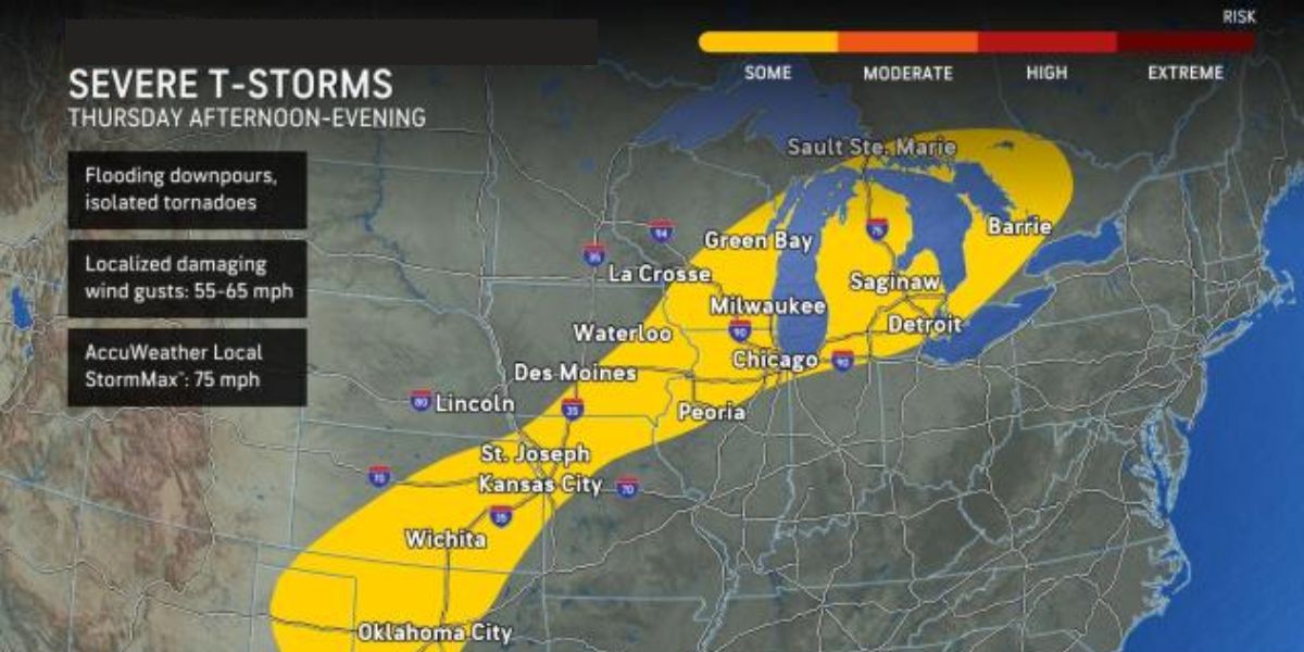
Strong, destructive winds and occasional storms
many gusts of between 70 and 80 mph were recorded in many locations during Wednesday night as the storms that began late Wednesday continued to rumble and lash parts of Iowa. A gust of 82 mph was recorded at Carroll, Iowa.
The thunderstorms will move further to the east and south into Friday due to a bubble of slightly cooler and drier air. From central and southeast Ontario to northwest Texas, thunderstorms—some severe with destructive wind gusts—will persist through Thursday night.
Parts of the metro areas of Chicago, Detroit, Oklahoma City, and Kansas City, Missouri, may be impacted by the storms during this time.
On Friday, the Northeast will see a shift in the chance of severe thunderstorms.
The main risk of severe thunderstorms in the afternoon and evening will stretch from northeastern and north-central Pennsylvania to northwestern New Jersey and a portion of the Interstate 95 corridor in Maine.
New York City, the South Coast of New England, and maybe Philadelphia and Harrisburg, Pennsylvania, might all see thunderstorms.
Additionally, on Thursday night and Friday, the chance of severe weather will shift further to the west.
From northeastern New Mexico to eastern Colorado, central and eastern Wyoming, and a portion of western Nebraska, storms with the potential to produce severe winds and locally damaging hail are expected to move throughout the region Thursday afternoon and evening.
From eastern Wyoming, the Nebraska Panhandle, and northeastern Colorado, a few strong storms are expected to make landfall in parts of southern Manitoba and Saskatchewan, Canada. At the local level, storms with destructive wind gusts and hail will be important.
From northern and central Illinois to coastal regions from southern New Jersey to Delaware and Maryland, thunderstorms with the potential to produce gusty winds are expected to be present on Saturday. Many of these storms might not be severe, but some have the potential to intensify into dangerous wind gusts throughout the afternoon and early evening.
Read Also: Triple-Digit Heat, Health Warnings in Effect for Louisville Through July 30
The northern edge of the heat to the south and east is where the storms are most likely to occur this weekend.
Much colder and less humid air will finally be able to move from the Midwest into the Northeast due to a significant change in the jet stream that will occur from later this weekend to the middle of next week.
Nonetheless, during that shift, one or more rounds of strong thunderstorms are predicted to move over parts of the mid-Atlantic and New England in the middle of next week, as well as from the Dakotas to the Great Lakes region from Sunday to Tuesday.
During some of the more intense thunderstorm rounds, wind gusts can be severe enough to harm trees, property, and power lines.
Multiple rounds of thunderstorms are expected to move across a wide area from the Texas Panhandle northeastward through western Wisconsin and Illinois between Thursday and Friday night. The risk of flooding will be highest in a more concentrated area between central Iowa and southern Kansas.
With widespread totals of 1-2 inches anticipated throughout the Plains and Midwest, several locations will be able to swiftly accumulate several inches of precipitation.
Four inches of rain can accumulate rapidly in areas where thunderstorms frequently pass over the same region, from southern Kansas to central Iowa.
On Saturday, the risk of flash floods will move further eastward, encompassing coastal regions of Maryland, Delaware, and southern New Jersey as well as eastern Iowa and Missouri.
During the downpours, drivers on the highways in this area will at the very least encounter ponding and impaired visibility.
When storm drains are overloaded or rainfall concentrates on a tiny stream’s watershed, rising water levels may have an impact on some minor highways and city streets.


