An eastern North Carolina weather forecast warns beachgoers not to swim or surf as Hurricane Erin moves in and churns offshore, with red flags—some even double red flags—flying up and down the coast.
According to Ryan Ellis, a science and operations officer with the National Weather Service in Newport/Morehead City, it is just unsafe to go into the ocean at this time.
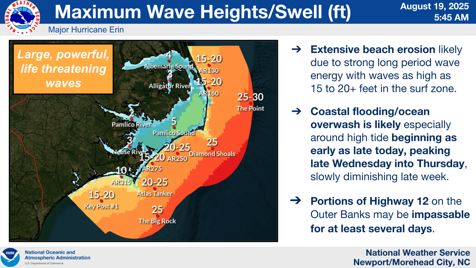
According to Ellis, waves as high as 20 feet will pose one of the greatest risks. We want to ensure folks stay secure since those are figures we don’t typically see. Longshore currents and rip currents are two examples of conditions that can endanger swimmers. As the storm draws near, our only goal is to keep people out of the ocean. We should certainly anticipate seeing those high rip current risks in place through this weekend because these things carry energy for a long time after they happen.
He clarified that the current wave heights at a few of the buoys have already risen to 8 to 10 feet. We anticipate that it will continue to rise, which will result in a lot of wave energy washing up on the beaches, causing coastal erosion, and maybe flooding Highway 12, rendering it unusable for a few days.
Shoreline communities around the North Carolina coast will be impacted, while the Outer Banks are probably going to be the most affected.
Even after the storm passes, Ellis predicted that those rip currents would remain strong today and throughout the remainder of the week. That is the first major hazard, but some of these areas will also see some of this wave action.
He added that people in locations that are prone to flooding should prepare for storm surges. Some of those low-lying localities, such as those in Down East Carteret County and a little further up the Neuse River, may see coastal flooding of one to three feet. You might experience some problems with this if you are in a situation where you are typically vulnerable and you are aware of that.
Ellis stated that although the winds will start to increase on Wednesday afternoon, Erin is not too concerned about that.
The wind doesn’t really concern us as much. “The problem is going to be with the wave energy that’s coming from this,” he said, adding that although tropical storm warnings are being issued, it is not what we expect to be the issue.
As Erin moves off to the Northeast, he anticipates that the storm’s effects will peak Thursday morning and then progressively diminish.


