Updated @ 9:15 PM EDT on August 21, 2025
After causing some road access issues in the Outer Banks and bringing rain, storm surge, and dangerous rip currents to coastal areas in North Carolina, Hurricane Erin is gradually leaving the U.S. Eastern Seaboard.
The National Hurricane Center (NHC) in Miami stated in its advisory at 8 p.m. ET on Thursday that the Category 2 storm’s center was approximately 420 miles northeast of Cape Hatteras, North Carolina, and was capable of sustained winds of 100 mph.
From Cape Lookout to Duck, North Carolina, a storm surge warning was still in force, warning of the potentially fatal risk of coastal flooding due to surging waters. For Bermuda, a tropical storm warning has been issued. According to the NHC, the tropical storm warning that was in effect from Duck, North Carolina, to Chincoteague, Virginia, was lifted.
Parts of the Outer Banks were seeing yet another round of flooding due to Thursday evening’s high tide, according to the Newport/Morehead City National Weather Service office.
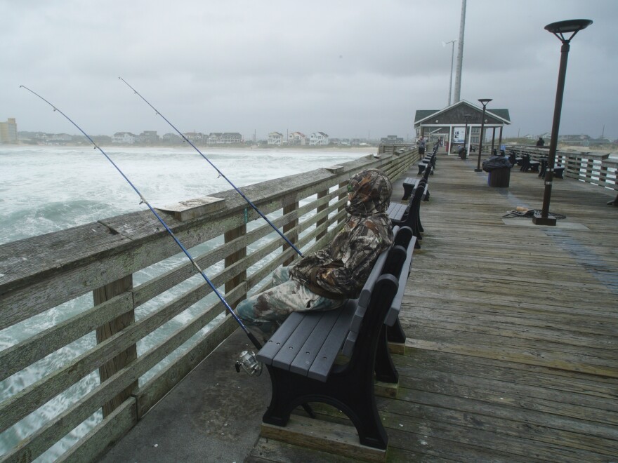
Forecasters have noted that Erin’s remarkable size, with tropical storm force winds affecting an area in the storm’s path that is more than 600 miles in circumference, is exceptional even though it did not make landfall.
Josh Stein, the governor of North Carolina, issued a warning Thursday that coastal flooding and hazardous rip currents would persist over the weekend. “Please refrain from driving on roads with standing water as flooding is expected to peak overnight. “We are keeping a close eye on the situation and are prepared to address any needs,” he added in a statement.
Hurricanes are common in the Outer Banks, a vulnerable chain of barrier islands that protrude into the Atlantic. Massive waves crashed into stilt-built seaside houses, and the ferry that connected Ocracoke Island to the mainland was shut down.
Northern Buxton, the area north of Hatteras Village, and northern Ocracoke Island had “extreme ocean overwash” due to Thursday morning’s high tide, according to the Island Free Press, which covers the Outer Banks. It said that Hatteras Village had also been submerged by water.
As stated by WAVYas, “It’s pretty par for the course living out here,” according to Leslie Coleman, an Outer Banks resident. “It’s certainly not one of the worst storms we’ve seen, but it’s got the waves coming up a little higher, eating at a little bit of our dunes.”
Tideland Electric Membership Corporation, a cooperative that supplies electricity to the Outer Banks, stated in a Facebook post on Thursday morning that Ocracoke had not lost power due to the hurricane. “Our crews are making their way to the north end of the island to inspect our infrastructure,” it read.
Over 2,000 locals and visitors complied with prior evacuation orders for the islands of Ocracoke and Hatteras.
Overnight, Highway 12, the only major route out, was blocked off when the storm surge broke over protective sand dunes. “Deep sand, water, and debris continue to cover the roadway,” the authorities of Dare County stated on Thursday morning in a social media post.
On Thursday night, the National Weather Service is warning of a persistent storm surge in the Outer Banks that could reach a height of four feet.
The Cape Hatteras Motel in Buxton’s property manager, Melinda Meadows, said WRAL that the majority of the sand barriers had vanished and a couple heat pumps have washed away.
Hurricane Helene, one of the most destructive hurricanes in North Carolina’s modern history, ripped through the western portion of the state less than a year ago. At least 250 people died because of Helene.
Further north, Erin’s effects were being felt. Through early Friday, experts predicted that the mid-Atlantic and southern New England coasts would see wind gusts with tropical storm force.
Strong winds from Erin are creating dangerous surf conditions and big, dangerous waves. Rip currents are also very likely to occur along most of the East Coast.
At Rockaway Beach in Queens, New York, surfer Scott Klossner was having fun with the enormous swell in spite of the advice to keep out of the water. “You look forward to these waves all year long. You’ve been waiting all year for this. He told The Associated Press, “This is it.”
Erin is presently heading northeast, away from the East Coast, and gaining speed, according to the NHC. It will pass across the western Atlantic between the United States and Bermuda through Friday. According to forecasters, it will progressively wane over the course of the next two days before dipping below the tropical storm threshold on Saturday.
Copyright 2025 NPR


