As Hurricane Erin moves toward the eastern coast of North Carolina, the prediction has not changed significantly.
Although Hurricane Erin is not projected to reach land, the Outer Banks are still expected to be most hit, according to the Newport/Morehead City National Weather Service. The storm is predicted to cause strong waves, hazardous rip currents, beach erosion, and coastal flooding.
Some of the effects are already being noticed in eastern North Carolina, according to Science and Operations Officer Ryan Ellis, but tomorrow Erin will truly make her presence known.
“The waves will keep getting bigger,” he stated. “By Thursday morning. We anticipate that to be the height of it, lasting until Thursday afternoon.
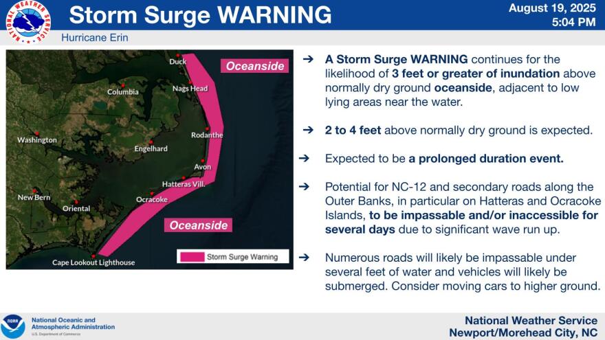
It is anticipated that the Outer Banks could experience a storm surge of three feet or more, with long-lasting effects, including the possibility that N.C. 12 would be impassable for many days. North Topsail Beach could get storm surges of up to three feet, while the Crystal Coast could see two to three feet. Ellis added, “You might see one to three in some of those sites along the Bogue Banks, up the Neuse River, and in some of those parts of Carteret County, down east. Areas farther west will have less flooding than those farther east, he continued.
Ellis stated that the waves might reach a height of 20 feet and that the weather service labeled them as “large, powerful, and life-threatening” as Hurricane Erin moves closer. High waves are predicted to inflict significant beach and coastal damage in areas along the ocean, which will see the maximum water levels from Wednesday through Friday. Thursday is when water levels will be at their maximum in soundside locations.
Due to hazardous rip currents, beaches throughout the North Carolina coast are issuing red flags, warning people not to surf or swim. Some are flying double red flags, which indicate that swimming is prohibited in the ocean and that anyone caught in the sea faces fines or even arrest.
Ellis stated that individuals in eastern North Carolina should still be able to stay up to date on storm forecasts in the future, even though the forecast for Erin has remained rather stable. Stay informed about the forecast. “We will continue to provide those updates as they come out from the Hurricane Center and what that means for our local area here,” he said, acknowledging that the forecast is always shifting.


