After some scattered showers moved through parts of eastern Iowa today, we’re getting a short break in the action.
This lull is expected to last through this evening and into portions of the night, possibly bringing a bit of clearing in some areas.
Later tonight, especially closer to daybreak, the chance for a few spotty showers returns. Temperatures overnight will dip into the upper 30s to around 40 degrees. Some fog may form overnight as well, particularly in northeastern areas.
By Thursday morning, scattered showers could pop up again as a low-pressure system moves in from the northwest. Cloud cover will be hit-or-miss, similar to today. Temperatures will rise to the low to mid-50s in the northeast and low to mid-60s in the southwest.
In the afternoon, there’s a better chance for additional development, thanks to daytime heating, the nearby low, and a bit of atmospheric instability.
This could trigger scattered showers and even a few thunderstorms, mainly for areas along and south of U.S. Highway 20, with the highest chances south of Interstate 80. While some heavier downpours are possible, the setup doesn’t support any severe storm threats.
Most of this activity will taper off by evening, leaving behind only a few isolated showers into the early nighttime hours.
Rainfall overall will remain light and scattered. Some areas may see a couple tenths of an inch in heavier spots, but many places won’t see much at all. Skies will begin to clear again Thursday night, with lows dipping back into the 30s.
Slight Cooldown Followed by a Warm-Up
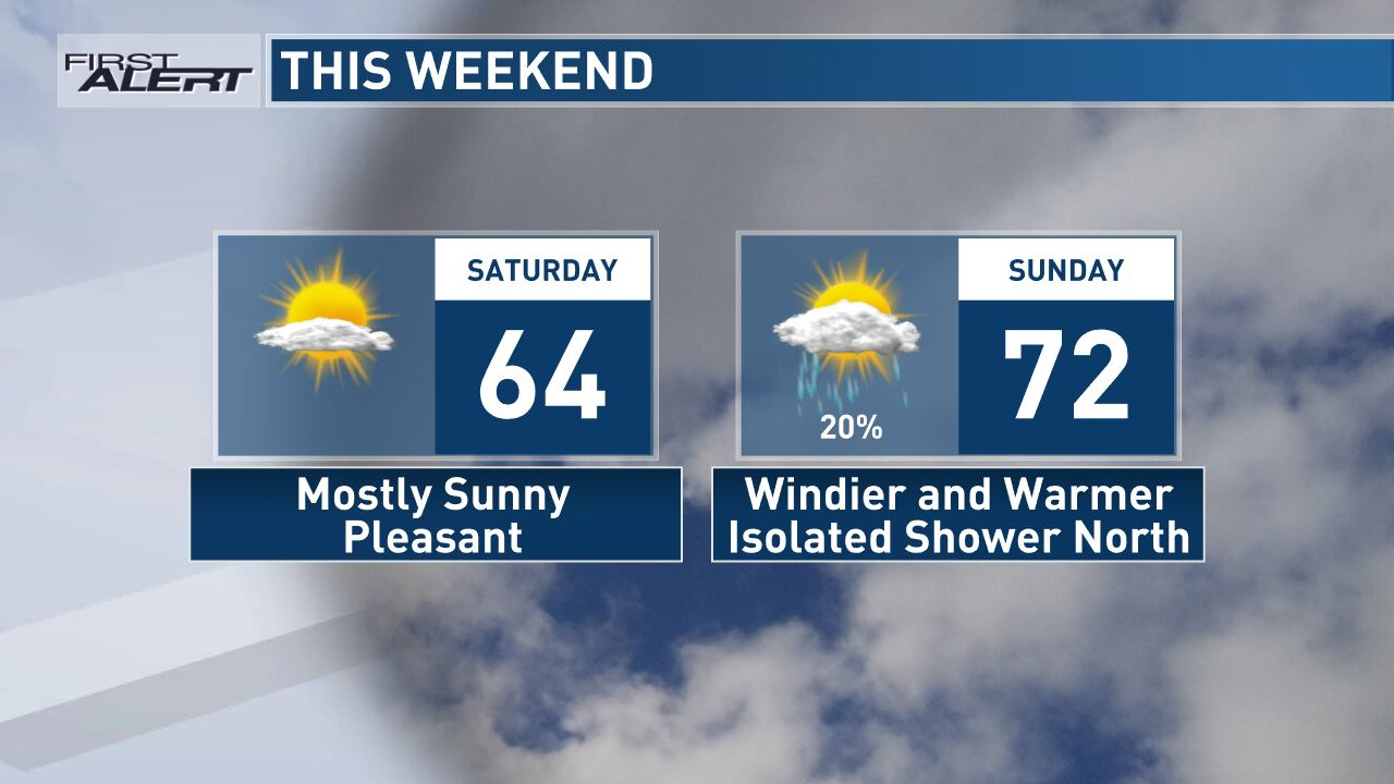
As we head into the weekend, winds will shift to a southerly direction, signaling a warm-up. Expect mostly sunny skies and daytime highs climbing into the 60s across much of the region.
Southern and western counties could even flirt with 70 degrees. Winds will be breezy, but Saturday will be the calmer of the two weekend days.
On Sunday, temperatures get an extra boost, likely reaching into the 70s. However, winds will also pick up, with gusts between 25 and 35 mph.
If you can handle the breeze, it’ll still be a great day to enjoy the outdoors. There’s also a slight chance for a few light showers early Sunday, mainly in northern parts of the area.
Cooler Start to the Week, Then Warming Again
A cold front is expected to move through on Monday, briefly capping our warming trend and bringing in cooler air. Highs should still manage to reach the 60s before the front passes. Behind it, winds will shift northwest with gusts up to 30–40 mph.
Tuesday brings the coolest day of the week, with lows in the 30s and highs in the 50s. Even so, temperatures will still be close to average for mid-April.
Looking ahead to late next week, temperatures rebound once again, with highs back in the 60s and lows in the 30s and 40s. A slim chance for a light shower or storm is possible by Thursday, but overall, it looks fairly dry.
Disclaimer- Our team has thoroughly fact-checked this article to ensure its accuracy and maintain its credibility. We are committed to providing honest and reliable content for our readers.


