Wednesday night, April 2, 2025, marked the most active tornado night of the year so far in Indiana, with a significant focus on central parts of the state.
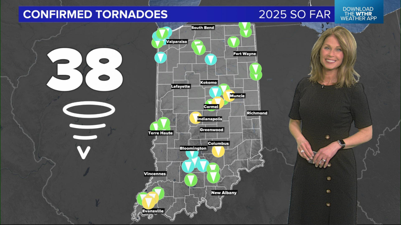
The National Weather Service has confirmed 18 tornadoes statewide, bringing the total number of tornadoes for 2025 to 38.
To view the National Weather Service recap of Wednesday night’s tornadoes and wind damage, click HERE.
We have created highly detailed survey maps for tornadoes that affected Brownsburg, Carmel, Lapel, Anderson, and Muncie.
The storm produced four EF-2 tornadoes, twelve EF-1 tornadoes, and two EF-0 tornadoes, along with significant wind damage across the state.
The map below shows the locations of the 18 tornadoes in Indiana:
- Yellow: EF-2
- Green: EF-1
- Blue: EF-0
A line of severe windstorms moved across the state from southwest to northeast, with notable rotation near Terre Haute.
This rotation evolved and cycled over time, leading to multiple tornadoes in the greater Indianapolis area and extending into the outskirts of Anderson and Muncie.
We have provided detailed maps for each tornado in central Indiana, including landmarks.
Other tornadoes occurred in western and northern Indiana, including two tornadoes near the Wabash River north of Terre Haute, twin tornadoes in Adams County, an EF-1 in Marshall County, and another in Steuben County near Angola. The weakest tornado was a brief EF-0 in Lawrence County near Heltonville.
Brownsburg EF-2 Tornado
- Start: 9:09 p.m., End: 9:21 p.m.
- Length: 9.57 miles
- Top Wind Speed: 120 mph
- Injuries: 1, Fatalities: 0
This tornado first touched down near Tilden and moved through downtown Brownsburg, staying south of City Hall but north of the school.
It tracked over the warehouse district on Northfield Drive, causing significant damage to the Sur La Table warehouse.
The tornado then crossed I-74, hitting homes near Raceway Road and Eagle Creek, and shutting down I-65 and Lafayette Road due to debris.
Carmel EF-1 Tornado
- Start: 9:28 p.m., End: 9:35 p.m.
- Length: 6.6 miles
- Top Wind Speed: 105 mph
- Injuries: 0, Fatalities: 0
This tornado, stemming from the same circulation that hit Brownsburg, touched down just south of Meridian Street/U.S. 31 and tracked northeast.
It stayed just south of the Carmel Arts and Design District and damaged homes on the east side of Carmel before ending near the White River, just before Conner Prairie.
Lapel EF-2 Tornado
- Start: 9:43 p.m., End: 9:46 p.m.
- Length: 2.15 miles
- Top Wind Speed: 125 mph
- Injuries: 0, Fatalities: 0
This brief yet strong tornado touched down over State Road 13 and tracked north along the southeastern outskirts of Lapel. Several homes in the area were damaged.
Madison County (Outskirts of Anderson) EF-1 Tornado
- Start: 9:46 p.m., End: 9:55 p.m.
- Length: 11.57 miles
- Top Wind Speed: 110 mph
- Injuries: 0, Fatalities: 0
Following the Lapel tornado, this new circulation created a longer tornado track across Madison County, damaging numerous homes and leaving debris on the roads. Madison County remained under a travel advisory for several days.
The tornado crossed West 8th Street Road and the White River, staying north of Anderson, before picking back up near State Road 9.
Delaware County (Outskirts of Muncie) EF-2 Tornado
- Start: 9:57 p.m., End: 10:17 p.m.
- Length: 16.16 miles
- Top Wind Speed: 125 mph
- Injuries: 0, Fatalities: 0
This longer and more dangerous tornado started in Madison County but quickly crossed into Delaware County, near I-69 and West McGalliard Road. It stayed out of Muncie but passed dangerously close to Wes-Del High School, possibly featuring multiple vortices.
The tornado continued northeast toward Anthony, Indiana, and ended near State Road 3, passing just a few miles northeast of Ball State and Delaware County Airport.
38 Tornadoes Confirmed for 2025 in Indiana
Indiana typically sees 20-30 tornadoes annually, and we’ve already exceeded that range, with tornado season peaking around mid-May.
The fastest start to tornado season since 2011, when 72 tornadoes were recorded, has set a concerning pace.
To explore breakdowns of earlier tornadoes this season, click HERE for the March tornadoes recap.
Disclaimer- Our team has thoroughly fact-checked this article to ensure its accuracy and maintain its credibility. We are committed to providing honest and reliable content for our readers.


