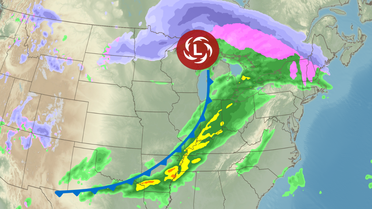
A dangerous and potentially historic flooding event is set to impact 22 million people from Arkansas to Ohio, with residents urged to prepare immediately.
Life-threatening flooding is expected from Wednesday night through Sunday morning as multiple rounds of heavy rain hit the same areas throughout the week.
Severe thunderstorms could bring tornadoes, damaging wind gusts up to 80 mph, and hail as large as tennis balls.
On Tuesday, a tornado watch was issued for parts of the southern Plains, including Texas, Kansas, and Oklahoma, covering the Oklahoma City metro area.
The watch remains in effect until midnight CT, with storms expected to intensify and move through the area during the evening.
Before the flooding begins, severe storms will hit the Heartland. More than 80 million people are under alert for this outbreak of dangerous thunderstorms.
On Wednesday, strong tornadoes, hail, and damaging winds could impact cities from Chicago and St. Louis to Indianapolis, Louisville, and Little Rock.
Some areas, including Little Rock, the Arkansas-Missouri border, Louisville, and Evansville, Indiana, could receive over a foot of rain. Residents should avoid flooded roads and prepare for possible power outages.
Meanwhile, on the northern side of the storm, heavy snow is expected in northern Minnesota. From Tuesday night to Wednesday night, six to 12 inches of snow could fall, with wind gusts reaching 40 mph.
Wintry conditions also persist from the Sierra Nevada to the Rockies, where winter weather alerts are in effect. Heavy mountain snow and strong winds could make travel hazardous, especially through mountain passes.
Winter weather alerts extend from North Dakota to Michigan, with worsening conditions expected by Tuesday night. Icy roads may disrupt travel, adding to ongoing power outages after a devastating ice storm in the northern Great Lakes region.
The National Weather Service warns of a “significant and widespread flooding” event from late Wednesday through the weekend, describing the situation as having the potential for “high impacts and life-threatening flash flooding” over several days.
Disclaimer- Our team has thoroughly fact-checked this article to ensure its accuracy and maintain its credibility. We are committed to providing honest and reliable content for our readers.


